This is first in a series of five articles. Access the second, third, fourth and fifth.
A new horizon was opening up before a group of learned gentlemen who gathered at the Raffles Library and Museum in Singapore on 28 February 1878 to attend the inaugural address of The Straits Branch of the Royal Asiatic Society. They were amongst the 45 ordinary and council members who saw a greater purpose in forming a Society to “promote the collection and record of information relating to the Straits Settlements and the neighbouring countries.”
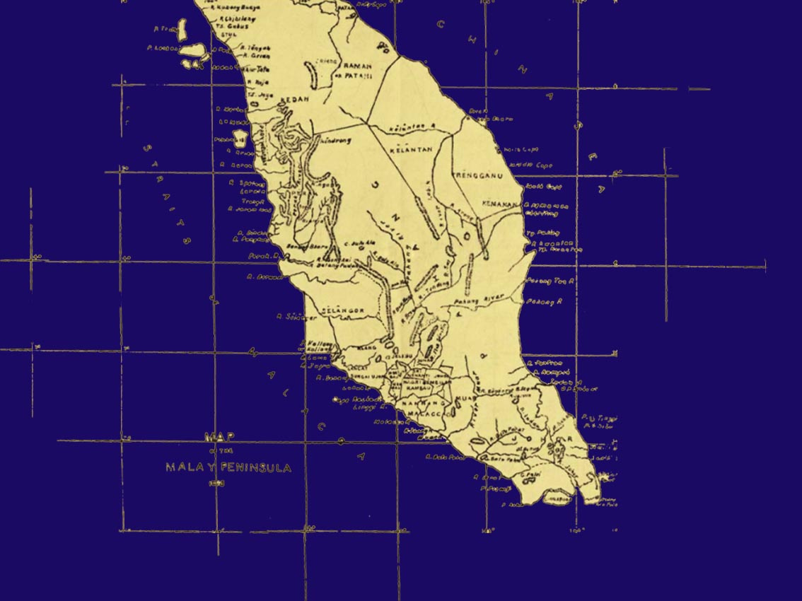
Accompanying the inaugural address was the exhibition of a large-scale Map of the Malay Peninsula. The map did not so much as illustrate complete knowledge over a geographical terrain. Instead, the science of cartography offered a roadmap and prospected a future enterprise.
The address delivered by then Society president, Venerable Archdeacon Hose, offered clues to this cartographical ambition. On the map, he pointed out, “observe the immense spaces which are entirely blank, or have merely the name of the native Government to which they are supposed to be attached written across them, such as Kelantan, Patani, Tringganu; and compare them with the few districts, almost entirely on the Western Coast, in which the mountains are sketched in, the course of the rivers traced, and the names of towns and villages inserted. Does it not remind some of us of what the map of Africa used to look like in our school days, before the discoveries of Livingstone and his successors?”
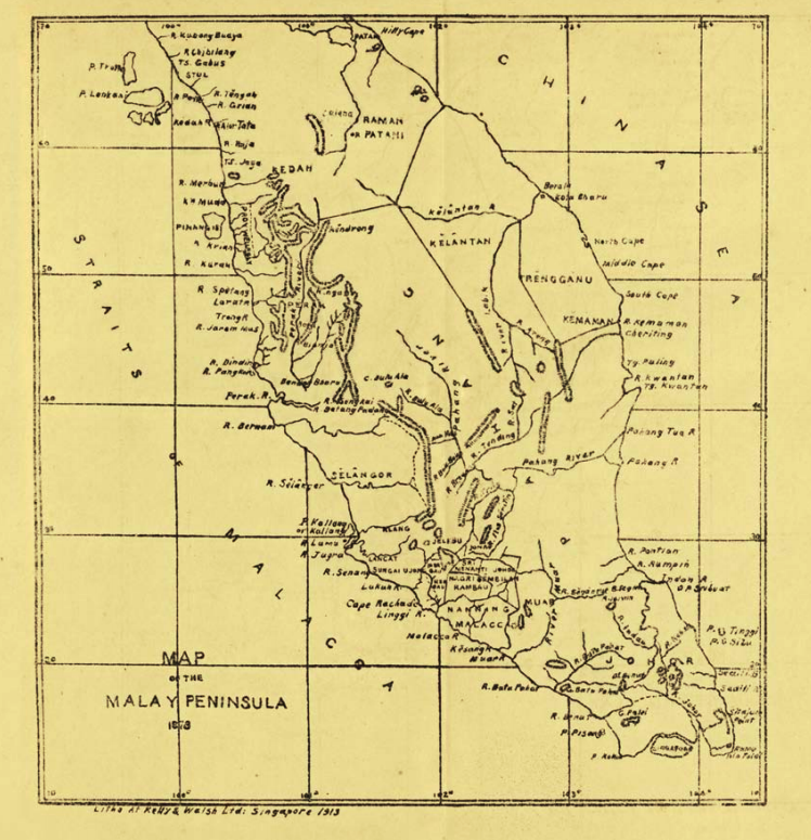
There is a technological dimension in how the map on display functioned as an image. One could consider it as a 19th-century version of a live-feed. Exhibited here was a map in the making. In its incomplete state, one notices that there remained areas yet to be named and contours yet to be filled, domains yet to be chartered. It was expected that new information would gradually fill in the blank areas as surveys are conducted or as information is received in the present time.
In effect, the map drew the audiences’ attention to the large extent of the Peninsula that remained unexplored. But it also spoke about the rapacious institution of knowledge building that had the means to ensure clockwork regularity in the collection of information – contemporaneous to the gathering for the inaugural address, in real time.
No other object captured the ideals, hubris, and foibles of this enterprise better than the exhibited Map of the Malay Peninsula. The map was more than a topographical record of a terrain. It indicated that a new economic imperative was shifting from control over bodies of water towards recognising new resources and wealth that can be harvested and mined that comes with knowledge over the land.
Therefore the map also promised adventure. In a prophetic plea, Hose enjoined those present at his address to consider how ’the map is also a sign that a great effort is being made to bring this state of ignorance to an end…. And think on what we know those great blanks must mean.’
Mapping was a technology that both records a past and charts a future. In his speech, president of The Straits Branch of the Royal Asiatic Society Archdeacon Hose recited a genealogy of forebears who contributed to Western knowledge of the Malay Archipelago. In names, he cited four – William Marsden, John Leyden, Stamford Raffles, and Thomas J. Newbold. He also noted that these scholars not only relayed but also vastly enriched accounts of Portuguese and Dutch travellers that came before.
However, the most important tribute was reserved for Scotland-born and Penang-naturalised polymath, James Richards Logan, who came to the island to practice law. In his legal work, Logan was known to have represented the rights of ‘sireh’ farmers against the East India Company and the Chinese community in their petition to conduct religious processions across town; even if his views on the local population remained deeply shaped by the racial prejudices of European colonial settlers.
He later took over as editor and, subsequently, the owner of Penang Gazette from 1853 onwards. The newspaper became his platform to advocate for the freedom of the Straits Settlements from Indian rule, which was secured when the Settlements gained its legislative autonomy after being made a Crown Colony in 1867. On this occasion, Logan was glorified for his near single-handed effort in putting together The Journal of the Indian Archipelago and Eastern Asia.
Interested in exploring the topic further? Here are some recommended sources, books and articles:
Primary Sources
1878. Journal of the Straits Branch of the Royal Asiatic Society, July. Inaugural issue. Available online at: http://www.sabrizain.org/malaya/library/jsbras/jsbras01.pdf
Rare Maps Collection. National Library Board, Singapore. Included under a sub-heading is the David Parry Southeast Asian Map Collection, comprising of 254 maps dating from the 15th to 19th centuries. http://eresources.nlb.gov.sg/printheritage/browse/Rare_Maps_Collection.aspx [Accessed 1 September 2019]
Further Reading
Benedict Anderson. 1991. ‘Census, Map. Museum’ in Imagined Communities: Reflections on the Origin und Spread of Nationalism, revised edition. London: Verso, 163-85. Available online at: http://jan.ucc.nau.edu/~sj6/AndersonCensusMap.pdf [Accessed 15 September 2019]
Irene Lim. 2016. ‘The Map that Opened Up Southeast Asia’ BiblioAsia 11:4, 30-1. Available online at: http://www.nlb.gov.sg/biblioasia/2016/01/22/the-map-that-opened-up-southeast-asia/ [Accessed 15 September 2019]
Carl A. Trocki. 2000. ‘Borders and the Mapping of the Malay World.’ in Association of Asian Studies Annual Meeting 9-12 March, San Diego, California. [Unpublished] Available online at: https://eprints.qut.edu.au/92/1/trockiBorderline.pdf
Er Jian Yeh. 2011. Territorialising Colonial Environments: A Comparison of Colonial Sciences on Land Demarcation in Japanese Taiwan and British Malaya. PhD thesis, Durham University. Available online at: http://etheses.dur.ac.uk/3199/